Stuff, Standards and Sites: Libraries and Archives in AR
William Denton
wtd@pobox.com
Background
William Denton
Web Librarian
York University, Toronto, Canada
Twitter: @wdenton | GitHub: wdenton
Slides: www.miskatonic.org/ar/arstandards10/
March 2014 AR Standards Community Meeting
26 March 2014, Arlington VA
CC-BY
Three things

One question
Is geolocation the missing ingredient?
1. Stuff

We have lots of it
and we want you to use it
King Suckerman

George Pelecanos (1997)
1816 R Street in fiction
Dimitri Karras swung the Ghia into a space in front of 1816 R Street, cut the engine.
“Here we are,” said Karras.
Vivian had a look at the building: a former mansion with a peeling stucco facade, now four floors housing three units per floor, a small yard out front patched with brown where a fat gray cat with huge ears lay on the grass watching a cluster of gnats hover in the air.
1816 R Street
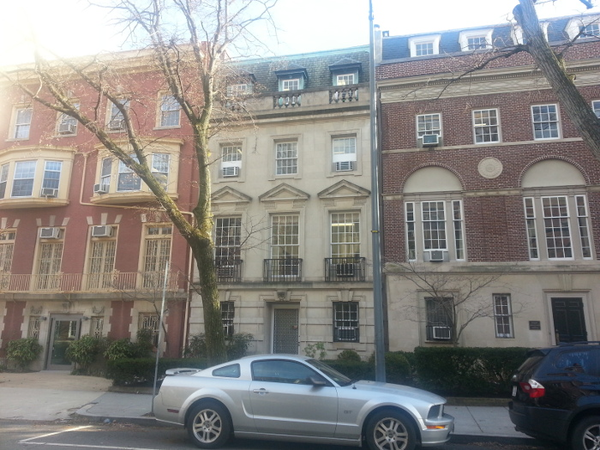
1812 on left, 1818 on the right
(38.912599, -77.04245)
(38.912599, -77.04245) is about what?
Ask MapFAST about (38.912599,-77.04245) and get JSON back
"Placemark": [
  {
    "id": "fst01316866",
    "name": "Washington (D.C.) -- Dupont Circle",
    "description": "",
    "point": {
      "coordinates": "38.9097,-77.0431"
    }
The important bit:
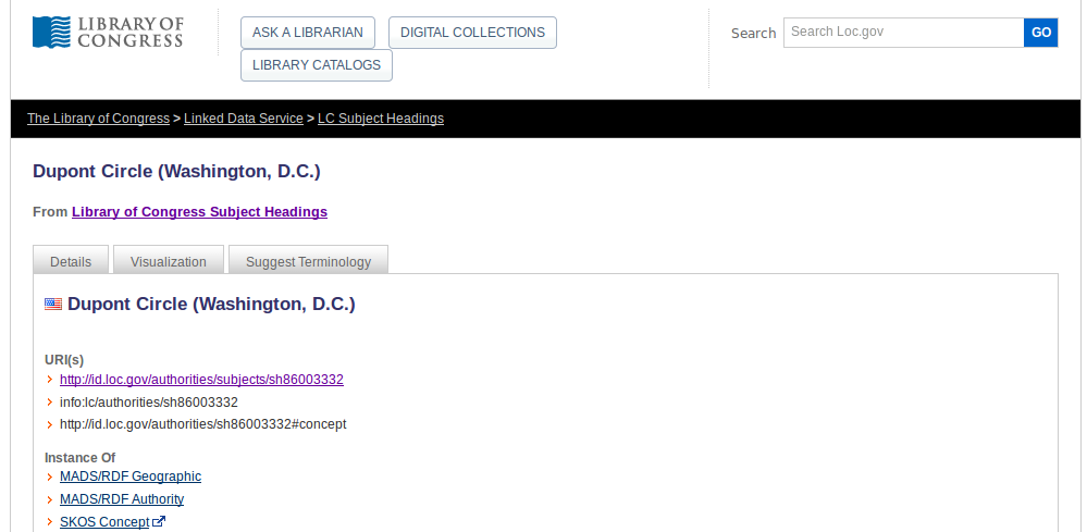
Washington (D.C.) -- Dupont Circle
That is a Library of Congress Subject Heading. We say “LCSH”
Sidebar: Subjects Here
See this in action yourself on your phone at
LCSH is a standard for aboutness
Library of Congress Subject Headings are a standard way of describing what things are about
LCSH is a standard we use to describe our stuff
2. Stuff is described by standards

Dupont Circle (Washington, D.C.)
Dupont Circle is linked
Dupont Circle in RDF
<madsrdf:authoritativeLabel xml:lang="en">Dupont Circle (Washington, D.C.)</madsrdf:authoritativeLabel>
<madsrdf:elementList rdf:parseType="Collection">
  <madsrdf:GeographicElement>
    <madsrdf:elementValue xml:lang="en">Dupont Circle (Washington, D.C.)</madsrdf:elementValue>
  </madsrdf:GeographicElement>
</madsrdf:elementList>
(MADS is the Metadata Authority Description Schema, used for describing things like this, which isn’t a thing like a picture of Dupont Circle but an “authority record”)
The thing to remember about library standards

We make standards to fit our specific needs: BagIt, BIBFRAME, Dublin Core, EAD, MADS, MARC, MODS, METS, OAI-PMH, ORE, PREMIS, RAD, RDA, …
For everything else we use web standards: Atom, GeoJSON, HTML5, JPEG2000, JSON, KML, RDF, RSS, XML, WKT …
We use your standards.
You can use ours!
They fit together.
LCSH → where?
<dct:identifier>1316866</dct:identifier>
<schema:name>Washington (D.C.)--Dupont Circle</schema:name>

<schema:sameAs>
  <rdf:Description rdf:about="http://sws.geonames.org/4138322/">
    <rdfs:label>Dupont Circle</rdfs:label>
  </rdf:Description>
</schema:sameAs>

<schema:geo>
  <schema:GeoCoordinates>
    <schema:latitude>38.90972</schema:latitude>
    <schema:longitude>-77.04305</schema:longitude>
  </schema:GeoCoordinates>
</schema:geo>
GeoNames to Wikipedia and …
<rdf:Description rdf:about="http://sws.geonames.org/4138322/">
<gn:countryCode>US</gn:countryCode>
<wgs84_pos:lat>38.90944</wgs84_pos:lat>
<wgs84_pos:long>-77.04333</wgs84_pos:long>
<wgs84_pos:alt>25</wgs84_pos:alt>

<gn:locationMap rdf:resource="http://www.geonames.org/4138322/dupont-circle.html"/>
<gn:wikipediaArticle rdf:resource="http://en.wikipedia.org/wiki/Dupont_Circle"/>
3. Standards are used on sites

Digital Public Library of America
API is searchable by location (gives JSON-LD)
Europeana
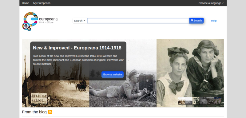
API is searchable by location (gives JSON)
Platforms

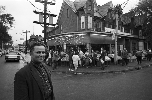
Geolocating photos in Kensington Market
York University Libraries has the photo archives from the old Toronto newspaper the Toronto Telegram (1876–1971), such as this photo from Kensington Market:
MODS: Metadata Object Description Schema
http://digital.library.yorku.ca/yul-89826/kensington-market/datastream/MODS/view
<identifier type="local">ASC12869</identifier>
<titleInfo>
  <title>Kensington Market.</title>
</titleInfo>
<abstract>Image of a man standing on a street corner near a fruit stand.</abstract>
<targetAudience>ASC Red Dot</targetAudience>
<name>
  <namePart>[Peter] Ward</namePart>
  <role><roleTerm authority="marcrelator" type="text">Photographer</roleTerm></role>
</name>
...
  <cartographics>
    <coordinates>43.654059, -79.400464</coordinates>
  </cartographics>
Location!
Dublin Core
http://digital.library.yorku.ca/yul-89826/kensington-market/datastream/DC/view
<dc:subject>Toronto Telegram--Portuguese Canadian History Project</dc:subject>
<dc:subject>Toronto Telegram--Portuguese Canadian History Project</dc:subject>
<dc:description>Image of a man standing on a street corner near a fruit stand.</dc:description>
<dc:contributor>[Peter] Ward (Photographer)</dc:contributor>
...
<dc:relation>Toronto Telegram fonds, F0433</dc:relation>
<dc:coverage>North America--Canada--Toronto</dc:coverage>
<dc:coverage>43.654059, -79.400464</dc:coverage>
Location!
Searching with Solr
/solr/yudl/select?
q=\{!geofilt+\}&
fl=dc.title,mods_originInfo_dateIssued_dt,mods_subject_cartographics_coordinates_ms&
wt=csv&
indent=true&
spatial=true&
pt=43.655,-79.4024&
sfield=mods_subject_cartographics_coordinates_coordinate&
d=1
“Show me everything you have within 1 km of (43.655, -79.4024)"
The results
| dc.title                                        | mods_...dateIssued_dt | mods_...coordinates_ms |
|-------------------------------------------------+-----------------------+------------------------|
| 133 Augusta Ave. : Valerie Agnes Riley Murdered | 1958-01-01T00:00:00Z  | 43.652289, -79.401119  |
| Food : Ways in which Food Arrives in Toronto    | 1971-04-20T00:00:00Z  | 43.652289, -79.401119  |
| Bellevue Ave. [not used]                        | 1955-01-01T00:00:00Z  | 43.652289, -79.401119  |
| Kensington Market.                              | 1965-10-16T00:00:00Z  | 43.654007, -79.400418  |
| Kensington Market.                              | 1965-10-16T00:00:00Z  | 43.654059, -79.400464  |
| Kensington Market.                              | 1965-10-16T00:00:00Z  | 43.654524, -79.401457  |
| Augusta Ave.                                    | 1958-11-08T00:00:00Z  | 43.655733, -79.40227   |
| Augusta Ave : Market [not used]                 | 1955-01-01T00:00:00Z  | 43.655162, -79.402421  |
| Augusta Ave : Market [not used]                 | 1955-01-01T00:00:00Z  | 43.65489, -79.402246   |
“Here is everything I have within 1 km of (43.655, -79.4024)"
Ready for a geolocated AR view.
Sites store the standards-described stuff
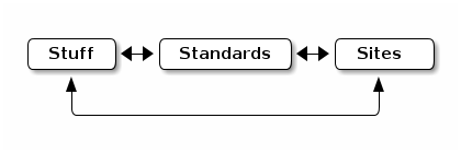
We have lots of stuff and we want you to use it
We use standards to describe our stuff
Some we made for our specific needs, others are web standards
Our sites use the standards to describe the stuff
and make it findable and usable